GS-3: Indian Economy and issues relating to planning, mobilization, of resources, growth, development and employment; e-technology in the aid of farmers; marketing of agricultural produce and issues and related constraints
Key Phrases: PMFBY, Crop Insurance, Satellite mapping, Drone-based data gathering, Crop-cutting Experiments, Agri-Startups, technological interventions, post-harvest yield estimates
Why in News?
- Government is planning to make use of technology (satellite mapping and drone-based data gathering in estimating yield of paddy and wheat) for the purpose of crop insurance under the Pradhan Mantri Fasal Bima Yojana (PMFBY), compulsory from kharif 2022.
Keypoints:
- With high accuracy level in Crop Cutting Experiments (CCEs),
technology adoption may eliminate data tampering possibility and build trust
in the crop insurance model.
- From the pilot projects done during last two seasons on wheat and paddy crop, the accuracy level of CCEs is between 80 and 95 per cent depending on technology used.
- By adopting the technology, the Agriculture Ministry has already roped in services of many private companies including agri start-ups who have invested in this segment, improving the data accuracy.
- Currently, CCEs are done in the pre-identified field in the presence of farmers, insurance company’s representatives and State officials.

Need for the step:
- Farmers allege that the manually done CCEs favour insurance companies by showing inflated yield than actual, insurers also claim that state officials reduce the yield to provide higher claims to farmers.
- The transition is essential for the government to retain the interest of private insurance companies after some of them exited from the crop insurance business, while no one participated during bids (for premium) in some clusters recently citing high claims ratio.
- Though the results of CCEs are supposed to be uploaded immediately in an app developed for the purpose, very often it does not happen and States take months to share the data, resulting in delays in claim settlement.
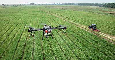
- Effective use of advance imaging technologies such as Multispectral, Hyperspectral and Thermal is possible with UAVs (drones) and this will help in analysing different aspects of crop physiology accurately.
Innovative Technologies being used in CCE:
- High Resolution Satellite data (Optical and microwave),
- Unmanned Aerial Vehicles (UAVs),
- Advanced multi-parameter crop models,
- Mobile Applications for Field Data Collection,
- Artificial intelligence/Machine learning approach,
- Sensor Networks and Internet of Things,
- Field based digital photographs,
- Hand held instruments and
- Scientifically designed Sampling Plans

Way Forward:
- Noise-free data and availability of that at hyperlocal level are indispensable for generating precise yield insights.
- Technology intervention in CCEs will be instrumental in nullifying aberrations to a significant level. Inconsistencies due to human error or bias are always a possibility, which can now be done away with technology providing near to accurate post-harvest yield estimates.
Related News:
- The government has released standard operating procedure (SoP)
for use of drones for the purpose of spraying pesticides on
agriculture crops.
- It covers important aspects like statutory provisions, flying permissions, area distance restrictions, weight classification, overcrowded areas restriction, drone registration, safety insurance, piloting certification, operation plan, air flight zones, weather conditions.
- Drone-based spray requires less amount of water, as well as pesticides, due to better application and bioefficiency.
Source: The Hindu BL
Mains Question:
Q. Analyse the feasibility to adopt suitable technology-based approaches for early settlement of claims in Crop Insurance Scheme. (150 Words).


