Relevance: GS-3: Conservation, environmental pollution and degradation, Disaster and disaster management.
Key phrases: Ministry of Earth Sciences, Indian coastline, sea-level rise, tropical storms and cyclones, shoreline erosion, GIS mapping, Hard structural, Groyne, Seawall, Offshore breakwater, Soft structural, Beach nourishment, Dune building, Coastal revegetation.
Why in News?
- West Bengal, Kerala and Tamil Nadu coastlines face the highest erosion in percentage terms.
Context:
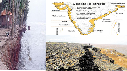
- The Ministry of Earth Sciences has informed that of the 6,907.18 km long Indian coastline of the mainland, about 34% is under varying degrees of erosion, while 26% is of the coastline is of an accreting nature, and the remaining 40% is in a stable state.
- India’s coastal regions, home to about 170 million of the country’s 1.4 billion people, are on the front lines of a shifting climate, experiencing sea-level rise, erosion, and natural disasters such as tropical storms and cyclones. The latest evidence of this vulnerability occurred in May 2020, as the strongest storm recorded in decades in the Bay of Bengal—Cyclone Amphan—hit, forcing several million people to evacuate
- The National Centre for Coastal Research (NCCR), Chennai, an attached office of the Ministry of Earth Sciences (MoES) is monitoring shoreline erosion since 1990 using remote sensing data and GIS mapping techniques. About 6,907.18 km long Indian coastline of mainland has been analysed from 1990 to 2018.
Erosion Data:

- The reasons for coastal erosions include
- Increase in frequency of cyclones and sea level rise and anthropogenic activities such as
- Construction of harbours,
- Beach mining and
- Building of dams.
Government measures for reducing coastal erosions
- There are 526 maps prepared for the entire Indian coast for identifying areas vulnerable to coastal erosion in 1:25000 scale along with 66 district maps, 10 state/UTs maps. A Report on 'National Assessment of Shoreline Changes along Indian Coast' was released in July 2018 and shared with various Central and state government agencies and stakeholders for implementing shore line protection measures.
- The MoES had successfully demonstrated innovative coastal erosion
mitigation measures at two pilot locations: Puducherry Beach Restoration
Project, Puducherry and Kadalur Periya Kuppam, Tamil Nadu.
- In Puducherry, the project 'Submerged Reef' has been implemented by MoES and beach nourishment is implemented by the government of Puducherry. This helped in restoration of the 1.5 kms long city beach after 30 years and helped in improving tourism and fishing activities in addition to protection of the coast during extreme cyclonic events.
- In case of Kadalur Periya Kuppam, wherein an offshore submerged dyke was implemented, it helped in protection of three fishing villages during extreme cyclonic events and restored lost beach that is being used for landing of fishing boats and other fishing activities.
- In addition, the NCCR is also providing technical support to state governments of Kerala (Chellanam, Kollamkode, Poonthura, Varkala and Shangumugham), Odisha (Ramayapatnam, Puri, Konark and Pentha), Andhra Pradesh (Vishakapatnam) and Goa for implementation of coastal protection measures at vulnerable stretches.
Method to Reduce Coastal Erosion:
- Hard structural/engineering options: Hard structural/engineering
options use structures constructed on the beach (seawalls, groynes,
breakwaters/artificial headlands) or further offshore (offshore
breakwaters). These options influence coastal processes to stop or
reduce the rate of coastal erosion.
- Groyne: A coastal structure constructed perpendicular to the coastline from the shore into the sea to trap longshore sediment transport or control longshore currents. This type of structure is easy to construct from a variety of materials such as wood, rock or bamboo and is normally used on sandy coasts.
- Seawall: A seawall is a structure constructed parallel to the coastline that shelters the shore from wave action. This structure has many different designs; it can be used to protect a cliff from wave attack and improve slope stability and it can also dissipate wave energy on sandy coasts.
- Offshore breakwater: An offshore breakwater is a structure that parallels the shore (in the nearshore zone) and serves as a wave absorber. It reduces wave energy in its lee and creates a salient or tombolo behind the structure that influences longshore transport of sediment.
- Artificial headland: This structure is constructed to promote natural beaches because it acts as an artificial headland. It is relatively easy to construct and little maintenance is required. The disadvantages are:
- Soft structural/engineering options: Soft structural/engineering
options aim to dissipate wave energy by mirroring natural forces and
maintaining the natural topography of the coast. They include beach
nourishment/feeding, dune building, revegetation and other non-structural
management options.
- Beach nourishment: The aim of beach nourishment is to create a wider beach by artificially increasing the quantity of sediment on a beach experiencing sediment loss, improving the amenity and recreational value of the coast and replicating the way that natural beaches dissipate wave energy.
- Dune building/reconstruction: Sand dunes are unique among other coastal landforms as they are formed by wind rather than moving waters; they represent a store of sand above the landward limits of normal high tides where their vegetation is not dependent on the inundation of seawater for stability.
- Coastal revegetation: Based on studies and scientific results, the presence of vegetation in coastal areas improves slope stability, consolidates sediment and reduces wave energy moving onshore; therefore, it protects the shoreline from erosion.
Way Forward:
- Coastal erosion and accretion are natural processes; however, they may become a problem when exacerbated by human activities or natural disasters. They are widespread in the coastal zone of Asia and other countries in the Indian Ocean owing to a combination of various natural forces, population growth and unmanaged economic development along the coast, within river catchments and offshore. This has led to major efforts to manage the situation and to restore the ability of the coast to accommodate short- and long-term changes induced by human activities, extreme events and sea-level rise. Understanding the key processes of coastal dynamics and how coasts are functioning both in spatial and temporal time scales (short and long term), in juxtaposition with human activities along the coast, within river watersheds and offshore is crucial for managing coastal erosion problems. Three main conclusions can be drawn on the roles that coastal forest and trees can play in combating coastal erosion:
- There is evidence that they provide some coastal protection and their clearance has increased the vulnerability of coasts to erosion. Based on scientific findings, the presence of vegetation in coastal areas will improve slope stability, consolidate sediment and diminish the amount of wave energy moving onshore, therefore protecting the shoreline from erosion.
- Increased interest in soft options (in this case the use of coastal forest and trees) for coastal protection is becoming predominant and is in line with advanced knowledge on coastal processes and the natural protective function of the coastal system.
- A combination of hard and soft solutions is sometimes necessary to improve the efficiency of the options and to provide an environmentally and economically acceptable coastal protection system.
Source: The Hindu
Mains Question:
Q. About one-third of India's coastline faces varying degrees of erosion, in this context discuss the measures to reduce the coastal erosion of India’s state. Critically examine.


