Relevance: GS-3: Science and Technology: developments and their applications and effects in everyday life.
Key phrases: EOS, Geo-Stationary orbit, Sun-synchronous orbit, mapping, ISRO, Kalpana EOS.
Why in News?
- The Indian Space Research Organisation (ISRO) has again deferred the launch of three earth observation satellites that were planned for the third and fourth quarter of the year, including the first development flight of what is likely to be a purely commercial small satellite launch vehicle.
What is Earth observation satellite?
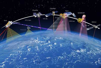
- An Earth observation satellite or Earth remote sensing satellite is a satellite used or designed for Earth observation from orbit, including spy satellites and similar ones intended for non-military uses such as environmental monitoring, meteorology, cartography and others.
- Earth observation satellites employ into Sun-synchronous quasi-periodical orbit.
Types of Orbit
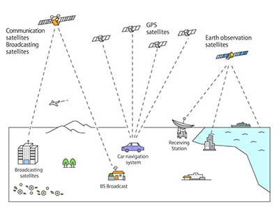
- Geostationary orbit: The geostationary orbit is used for communication, broadcasting and weather satellites. This orbit takes a position around the equator at a distance of 36000km from the Earth’s surface. Because the satellite moves at the same speed as the Earth’s rotation, the satellite maintains the same position over a certain point of the Earth’s surface.
- Low Earth orbit (LEO): A low Earth orbit (LEO) is, as the name suggests, an orbit that is relatively close to Earth’s surface. It is normally at an altitude of less than 1000 km but could be as low as 160 km above Earth – which is low compared to other orbits, but still very far above Earth’s surface.
- Medium Earth orbit (MEO): Medium Earth orbit comprises a wide range of orbits anywhere between LEO and GEO. It is similar to LEO in that it also does not need to take specific paths around Earth, and it is used by a variety of satellites with many different applications.
- Polar orbit and Sun-synchronous orbit (SSO): Satellites in polar orbits usually travel past Earth from north to south rather than from west to east, passing roughly over Earth's poles. The satellite on this orbit passes by a certain place of the Earth’s surface at the same local solar time (the orbit plane keeps a constant solar angle), so the satellite observes the same sun light reflection from the Earth’s surface.

Types of Earth observation satellite:
- EO satellites can be divided into two types based on how they capture imagery: passive and active.
- Passive satellites detect radiation reflected off the Earth’s surface, such as visible light and infrared. In general, passive satellites are not able to work through clouds.
- Active satellites transmit energy towards the Earth and measure the returned signal which provides information about the Earth’s surface. In general, active satellites can see through the cloud.
India’s Earth observation satellite
- Starting with IRS-1A in 1988, ISRO has launched many operational remote sensing satellites.
- Today, India has one of the largest constellations of remote sensing satellites in operation.
- Currently, 13 operational satellites are in Sun-synchronous orbit – RESOURCESAT-1, 2, 2A CARTOSAT-1, 2, 2A, 2B, RISAT-1 and 2, OCEANSAT-2, Megha-Tropiques, SARAL and SCATSAT-1, and 4 in Geostationary orbit- INSAT-3D, Kalpana & INSAT 3A, INSAT-3DR.
- Varieties of instruments have been flown onboard these satellites to provide necessary data in a diversified spatial, spectral and temporal resolutions to cater to different user requirements in the country and for global usage.
Application of Earth observation satellite:
- Environmental monitoring: satellites can assist environmental monitoring by detecting changes in the Earth's vegetation, atmospheric trace gas content, sea state, ocean color, and ice fields. By monitoring vegetation changes over time, droughts can be monitored by comparing the current vegetation state to its long-term average.
- Remote sensing data from EOS is used for varieties of applications in forestry and environment including Biodiversity characterization, Wetlands, Forest & Biomass mapping, Land Degradation and Desertification processes, Coastal wetlands, Coral reefs, Mangroves, Glaciers, Air and Water pollution assessment etc.
- Energy: Assessment of solar energy from Geostationary satellites like INSAT 3D & 3DR, ocean wind energy from Scatter meter data and ocean wave energy from Altimeter data & numerical models are being carried out. Monthly assured solar energy (kWhm-2) is derived using Kalpana-1 VHRR.
- Land Resources: Effective management of our natural resources is one of the important aspect for sustaining a healthy economy and move forward with regard to developmental agenda. Ex. Geo Tagging
- Rural Development: Various programmes are carried out by ISRO addressing the developmental priorities of the country for planning, monitoring and impact assessment viz. Monitoring of Integrated Watershed Management Programme (IWMP), Space Based Information Support for Decentralized Planning (SISDP), and GIS implementation of MGNREGA (Geo MGNREGA).
- Water Resources: Remote Sensing helps in better assessment and management of water resources, due to the synoptic coverage and possibilities of revisit from the EO constellation of satellites
Source: Indian Express
Mains Question:
Q. what do you understand by earth observational satellites? How these space programme boost India's soft power in Indian ocean region?


