
Daily Static MCQs Quiz for UPSC, IAS, UPPSC/UPPCS, MPPSC. BPSC, RPSC & All State PSC Exams
Subject : Geography
1. Consider the following pairs:
| Ocean currents | Oceans |
| 1. Labrador | Pacific Ocean |
| 2. Gulf stream | Indian Ocean |
| 3. Canary | Atlantic Ocean |
| 4. Humboldt | Pacific Ocean |
How many pairs given above are correctly matched?
(a) One pair only
(b) Two pairs only
(c) Three pairs only
(d) All four pairs
Answer: (B)
Explanation:

- The Labrador Current is formed by very cold − 1.5°C water from the Baffin Island Current and a branch of the West Greenland Current, which merges on the western side of the Labrador Sea (In the Atlantic Ocean). The current flows southward from Hudson Strait to the southern edge of the Grand Banks of Newfoundland. Hence pair 1 is not correctly matched.
- Gulf Stream, warm-ocean current flowing in the North Atlantic northeastward off the North American coast between Cape Hatteras, N.C., U.S., and the Grand Banks of Newfoundland, Can. In popular conception the Gulf Stream also includes the Florida Current (between the Straits of Florida and Cape Hatteras) and the West Wind Drift (east of the Grand Banks). Hence pair 2 is not correctly matched.
- Canary Current, also called Canaries Current, part of a clockwise-setting ocean-current system in the North Atlantic Ocean. It branches south from the North Atlantic Current and flows southwestward along the northwest coast of Africa as far south as Senegal before turning westward to eventually join the Atlantic North Equatorial Current. The cool temperature of the water is produced by upwelling caused by offshore winds from the continent. As the current flows around the Canary Islands, it helps to lessen the heating effect of the Sahara to the east. The thermal mixing creates excellent fishing grounds in the region. Hence pair 3 is correctly matched.
- Peru Current, also called Humboldt Current, cold-water current of the southeast Pacific Ocean. It is an eastern boundary current similar to the California Current of the North Pacific. The West Wind Drift flows east toward South America south of latitude 40° S, and while most of it continues through the Drake Passage around the southern tip of South America to the Atlantic, a shallow stream turns north to parallel the continent as far as latitude 4° S, where it turns west to join the Pacific South Equatorial Current. Hence pair 4 is correctly matched.
- As it is a cold current, except at times of the phenomenon known as El Niño, the Peru Current brings fog to the nearby coast but also helps to keep the coast one of the most intensely arid areas in the world. The cold flow is intensified by upwelling of deep water caused by the combined effects of the drag of surface winds of the Southeast Trades and the Earth’s rotation.
Hence, option (b) is correct.
2. With reference to coastal plains in India, consider the following statements:
1. The western coastal plains are submerged coastal plains
and the eastern coastal plains are emergent coastal plains.
2. Like in the eastern coastal plains, the rivers flowing through the western
coastal plain do not form any delta.
Which of the statements given above is/are correct?
(a) 1 only
(b) 2 only
(c) Both 1 and 2
(d) Neither 1 nor 2
Answer: (A)
Explanation:
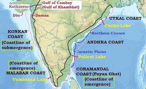
- The western coastal plains are an example of a submerged coastal plain. It is believed that the city of Dwaraka which was once a part of the Indian mainland situated along the west coast is submerged under water. Hence, statement 1 is correct.
- Because of this submergence, it is a narrow belt and provides natural conditions for the development of ports and harbours. Kandla, Mazagaon, JLN port Navha Sheva, Marmagao, Mangalore, Cochin, etc. are some of the important natural ports located along the west coast.
- Extending from the Gujarat coast in the north to the Kerala coast in the south, the west coast may be divided into the following divisions – the Kachchh and Kathiawar coast in Gujarat, Konkan coast in Maharashtra, Goan coast and Malabar coast in Karnataka and Kerala respectively.
- The western coastal plains are narrow in the middle and get broader towards the north and south. The rivers flowing through this coastal plain do not form any delta.
- As compared to the western coastal plain, the eastern coastal plain is broader and is an example of an emergent coast.
- There are well-developed deltas here, formed by the rivers flowing eastward into the Bay of Bengal. These include the deltas of the Mahanadi, the Godavari, the Krishna and the Kaveri. Because of its emergent nature, it has fewer ports and harbours. The continental shelf extends up to 500 km into the sea, which makes it difficult for the development of good ports and harbors. Hence, statement 2 is not correct.
Hence, option (a) is correct.
3. With reference to the landforms, the rock pedestals, zeugen, yardangs, and deflation hollows are associated with:
(a) arid or desert landforms
(b) glacial landforms
(c) coastal landforms
(d) groundwater landforms
Answer: (A)
Explanation:
- About a fifth of the world's land is made up of deserts, some rocky, others stony and the rest sandy. Desserts that are absolutely barren and where nothing grows at all are rare and they are better known as true deserts.
- Landforms of Wind Erosion in Deserts: In the combined processes of abrasion, deflation and attrition, a wealth of characteristic desert landforms emerge.
- Rock pedestals or mushroom rocks:
- The sand- blasting effect of winds against any projecting rock masses wears back the softer layers so that an irregular edge is formed on the alternate bands of hard and soft rocks. Grooves and hollows are cut in the rock surfaces, carving them into fantastic and grotesque looking pillars called rock pedestals. Such rock pillars will be further eroded near their bases where the friction is greatest. This process of under-cutting produces rocks of mushroom shape called mushroom rocks or gour in the Sahara.
- Zeugen:
- These are tabular masses which have a layer of soft rocks lying beneath a surface layer of more resistant rocks. Mechanical weathering initiates their formation by opening up joints of the surface rocks. Wind abrasion further eats into the under- lying softer layer so that deep furrows are developed.
- Yardangs:
- Quite similar to the ridge and furrow landscape of Zeugen are the steep-sided yardangs. Wind Abrasion excavates the bands of softer rocks into long, narrow corridors, separating the steep-sided over-hanging ridges of hard rocks, called yardangs. They are commonly found in the Atacama Desert, Chile, but the more spectacular ones with yardangs rising to 25-50 feet are best developed in the interior deserts of Central Asia where the name originated.
- Ventifacts or dreikanter:
- These are pebbles faceted by sand-blasting. They are shaped and thoroughly polished by wind abrasion to shapes resembling Brazil nuts. Rock fragments, mechanically weathered from
mountains and upstanding rocks are moved by wind and smoothed on the windward side.
- Deflation hollows:
- Winds lower the ground by blowing away the unconsolidated materials, and small depressions may form. Similarly, minor faulting can also initiate depressions and the eddying action of on-coming winds will wear off the weaker rocks until the water table is reached. Water then seeps out forming oases or swamps, in the deflation hollows or depressions.
Hence option (a) is the correct answer.
4. Consider the following statements regarding Jet Streams.
1. Jet streams are narrow bands of strong winds that flow
over thousands of kilometers predominantly from east to west.
2. Major jet streams are found near the upper levels of the atmosphere, around 9
to 16 km from the earth’s surface.
3. In India, the Tropical jet stream influences the formation and duration of
the summer monsoon.
4. Jet streams can aid in the faster traveling of Aircrafts.
How many of the above statements are correct?
a) Only one
b) Only two
c) Only three
d) All four
Answer: (C)
Explanation: Jet streams are narrow bands of strong winds that flow over thousands of kilometers from west to east. Hence, statement 1 is not correct.
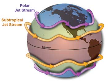
Why do jet streams move from west to east?
The jet stream exists, in general, due to convergence of air at the boundaries of the Earth's circulation cells: the polar cell and Ferrel cell, and the Ferrel cell and Hadley cell. These winds get deflected from their motion across latitudes due to the Coriolis effect. They are deflected to the left in the southern hemisphere and to the right in the northern hemisphere. In both hemispheres, this results in an easterly resultant wind direction.
Major jet streams are found near the upper levels of the atmosphere, around 9 to 16 km from the earth’s surface, and can reach speeds of over 320 kph. The jet streams shift to the north or south depending on the season. During winters, the wind current is the strongest. They are also closer to the Equator during winter. The major jet streams are the Polar Front, Subtropical, and Tropical jet streams.
In India, the Tropical jet stream influences the formation and duration of the summer monsoon.
Hence, statements 2 and 3 are correct.
Most commercial planes fly at the jet stream level, and a strong jet stream can provide a potent tailwind to a flight traveling from west to east. Hence, statement 4 is correct.
Hence, option (c) is correct.
5. The Peninsular Plateau (Deccan Plateau) region of India extends over which of the following states?
1. Rajasthan
2. Madhya Pradesh
3. Tamil Nadu
4. Jharkhand
Select the correct answer using the code given below.
(a) 1 and 2 only
(b) 2 and 3 only
(c) 3 and 4 only
(d) 1, 2, 3 and 4
Answer: (D)
Explanation:
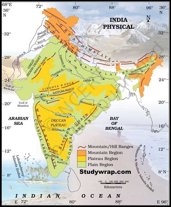
- The plateau region situated in the south of the Great Plains and surrounded by seas on three sides is known as Peninsular India. It is a triangular plateau with its base in the north which coincides with the southern edge of the Great Plains and its apex is formed by Kanyakumari.
- It extends over southeastern Rajasthan, Madhya Pradesh, Chhattisgarh, Telangana, and parts of Andhra Pradesh, Karnataka, Orissa, Tamil Nadu, as well as Jharkhand. It has an outlier in Meghalaya in the east. It is surrounded by the hill range on all three sides. To its north are the Aravalli, the Vindhyan, the Satpura, and the Rajmahal hills. Along with its western and eastern edges are the Western Ghats and the Eastern Ghats respectively. The entire plateau measures about 1600 kms in the north to south and 1400 kms in the west to east directions. It includes:
- East Rajasthan Uplands: It lies east of the Aravalli ranges also known as Marwar Upland with an elevation ranging between 250-500 m. It slopes eastwards
- The Central Uplands: The central uplands are also known as Madhya Bharat Pathar located in the east of Marwar uplands. Most of it comprises the basin of Chambal river. The area is famous for ravines and badlands.
- Chhota Nagpur Plateau: Lying to the west of the Bengal basin and east of Baghelkhand,
- Chhotanagpur Plateau covers mostly Jharkhand, northern Chhattisgarh, and the Purulia district of West Bengal.
- Deccan Plateau: This is the largest unit of the peninsular plateau of India covering an area of about 5 lakh sq. kms. This triangular plateau lies between Eastern and the Western Ghats and Satpuras and Vindhyan hills in the northwest, Mahadev and Maikal hills in the north.
Hence option (d) is the correct answer.


