
Context:
To strengthen agricultural monitoring in India, ISRO’s National Remote Sensing Centre (NRSC) has developed a semi-automated, scalable framework called Comprehensive Remote Sensing Observation on Crop Progress (CROP). This framework provides near real-time assessment of crop sowing, growth, and harvesting. Implemented during the 2024–25 Rabi season, the framework focuses on wheat cultivation across India.
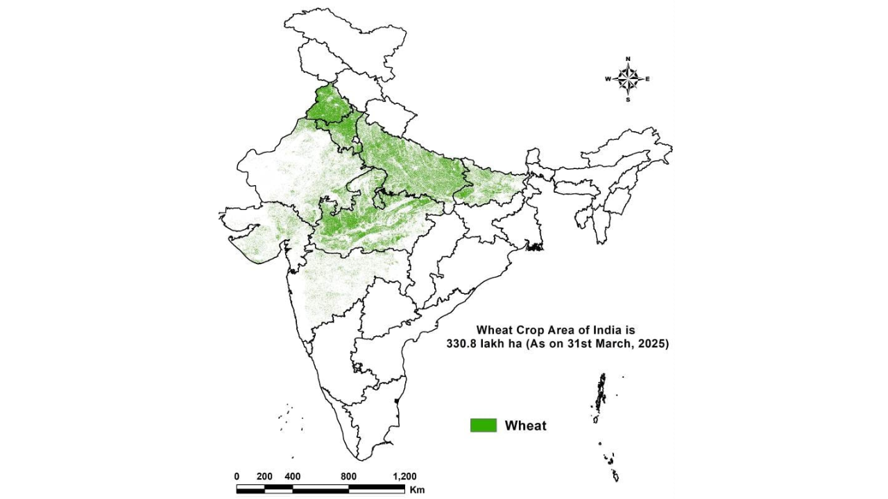
Key Findings
Wheat Sown Area: As of March 31, 2025, satellite analysis estimated wheat sowing at 330.8 lakh hectares, closely matching the Ministry of Agriculture & Farmers Welfare’s figure of 324.4 lakh hectares (as of February 4, 2025), confirming the accuracy of the remote sensing approach.
Crop Health and Weather Impacts
- January 2025: Conditions were stable with timely sowing and healthy vegetative growth in Punjab, Haryana, and Uttar Pradesh.
- February 2025: Rising temperatures and rainfall deficits posed risks of heat stress during grain filling stages.
- March 2025: Favorable weather supported recovery, and crop maturity progressed well. By late March, Rabi crops exhibited resilience, leading to optimistic projections.
Harvest Progress: Harvesting began in December 2024 and steadily progressed through January, February, March, and the first week of April 2025, marking a successful harvest timeline.
Estimated Wheat Production: As of March 31, 2025, wheat production across the eight major states was estimated at 122.7 million tonnes, based on the integrated crop simulation model and satellite data.
About CROPS:
CROP aims to systematically monitor wheat crop progress using advanced satellite data. It has been deployed across eight major wheat-growing states:
- Uttar Pradesh
- Madhya Pradesh
- Rajasthan
- Punjab
- Haryana
- Bihar
- Gujarat
- Maharashtra
Methodology
Satellite-Based Monitoring: CROP integrates multi-source data from both optical and Synthetic Aperture Radar (SAR) satellites, including:
- EOS-04 (RISAT-1A)
- EOS-06 (Oceansat-3)
- Resourcesat-2A
This combination enables continuous tracking of sowing progress, vegetation health, and drought stress.
Vegetation Health Index (VHI): The Vegetation Health Index (VHI) is used to monitor vegetation stress and overall crop condition. Monthly evaluations highlight changes in environmental factors affecting wheat growth.
Crop Growth Simulation: An experimental crop growth simulation model at 5 km × 5 km spatial resolution assimilates satellite-derived inputs (sown area, sowing dates, and crop condition) to estimate wheat yield, allowing precise national-scale forecasting.
Significance and Future Prospects
The CROP framework serves as a proof-of-concept for operational scalability in agricultural monitoring. It demonstrates potential in:
- Real-time tracking of sowing and harvesting
- Monitoring drought and crop health
- Enhancing yield estimation accuracy
With further refinement and automation, the framework can support data-driven agricultural planning and food security strategies at national and regional levels.
Conclusion
ISRO’s CROP framework exemplifies innovation in agricultural surveillance through satellite technology. Its successful implementation for the 2024–25 Rabi season highlights its potential as a strategic tool for improving agricultural resilience and policy planning in India.


