Line of Actual Control and Hot springs
Context:
Recently India and China held he 13th round of corps commander talks at Moldo on the Chinese side with focus on working out the third phase of disengagement from patrolling point 15 in Hot springs which is part of overall disengagement and de-escalation along the LAC in Eastern Ladakh.
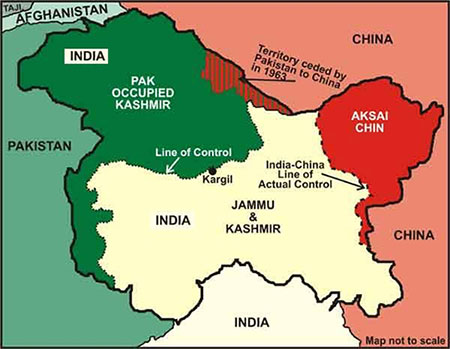
Line of Actual Control (LAC) :
- The LAC is the demarcation that separates Indian-controlled territory from Chinese controlled territory.
- India considers the LAC to be 3488 km. long, while the Chinese consider it to be only around 2000 km.
- LAC is divided into three sectors-
- The eastern sector which spans Arunachal Pradesh and Sikkim.
- The middle sector in Uttarakhand and Himachal Pradesh.
- The Western sector in Ladakh.
- The alignment of the LAC of the eastern sector is along the 1914 McMahon Line and the major disagreements are in the western sector.
- The LAC emerged from two letter written by Chinese PM Zhou Enlai to PM Jawaharlal Nehru in 1954, after he had first mentioned such line in 1956 which consisted of the so-called McMahon Line in the east and the line up to which each side exercises actual control in the west.
- After the 1962 War, the Chinese claimed that they had withdrawn to 20 km behind the LAC and Zhou in another letter to Nehru clarified LAC “to put it concretely, in the eastern sector it coincides in the main with the so-called McMahon Line and in the western and middle sector it coincides in the main with the traditional customary line which has consistently been pointed out by China.”
- India always rejected the concept on LAC in both 1959 and 1962. India’s stand was that the Chinese Line was a disconnected series of points on a map that could be joined up in many ways, the vagueness of the Chinese definition left it open for China to continue its creeping attempt to change facts on the ground by military force.
- India formally accepted the whole concept of the LAC when PM PV Narsimha Rao visited Beijing in 1993 and the two sides signed the Agreement to Maintain Peace and Tranquillity at the LAC. The reference to the LAC was unqualified to make it clear that it was not referring to 1959 or 1962 LAC but the LAC at that time of agreement.
According to India, LAC is not the claim line and India’s claim is the line seen in the official boundary marked on the maps released by the Survey of India, including Aksai Chin and Gilgit- Baltistan whereas China claims entire Arunachal Pradesh as South Tibet.
In 1954, PM Nehru issued a directive that “ all our old maps dealing with this frontier should be carefully examined and where necessary , withdrawn. New maps should be printed showing our northern and north eastern frontier without any reference to any line.”
He said that new maps should also be sent to embassies abroad and this map is officially used till date, formed the basis of dealings with China , leading to 1962 war.
Hot Springs-
- Hot springs traditionally known as Kyam is a campsite and the location of an Indian border check post- patrol point 15 at the Chang Chenmo river valley in Ladakh.
- The spot was so named due to the presence of a hot spring in the area, it is one of the four points where India and China had dispute during stand off in May 2020.
- The three other points of friction are Patrol point 17A near the Gogra Post, Patrol point 14 in Galwan valley and northern bank of Pangong Tso.
- After the last round of the talks which is 12th round- India and Chinese troops pulled back from the Patrol point 17A near Gogra Post.