Context:
The rapid advancements in automated systems and vehicles have led to a growing demand for increasingly sophisticated sensor technology enabling another emerging technology to progress remarkably and come into prominence, namely, Light Detection and Ranging (LiDAR). This advancement has raised global concerns, particularly about the growing dominance of Chinese firms in the LiDAR market and the associated national security risks.
What is LiDAR?
LiDAR is a dual-use remote sensing technology that employs light in the form of a pulsed laser to measure distances and map the surrounding environment. Unlike radar, which uses microwaves, and sonar, which uses sound waves, LiDAR's use of reflected light offers superior speed, precision, and resolution. This technology is advantageous over cameras due to its functionality in any lighting condition and its superior detection range.
Though LiDAR systems became commercially available in 2008, they were initially expensive, bulky, and required frequent maintenance. The significant interest in autonomous vehicles has driven technological improvements, making LiDAR systems more powerful, efficient, and cost-effective. The integration of LiDAR with artificial intelligence has further enhanced object recognition and classification capabilities.

Applications of LiDAR
● Automotive Industry: LiDAR is crucial for advanced driver-assistance systems (ADAS) and autonomous vehicles, providing 3D mapping for navigation, lane-keeping, and collision avoidance. The global automotive LiDAR market was valued at US$ 332 million in 2022, with Tesla purchasing over US$ 2 million worth of LiDAR equipment from Luminar.
● Agriculture: Used to monitor crop conditions and soil health.
● Weather Forecasting: Measures temperature, cloud cover, air density, and other atmospheric parameters.
● Geology and Mining: Maps and surveys landscapes.
● Smart Cities: Integrates with other technologies for utilities, transportation, and infrastructure.
● Military: Supports autonomous navigation for uncrewed ground and aerial vehicles, aids in battle damage assessment, and contributes to various military functions like target identification and mapping.
|
LiDAR in India ● Versatile Applications of LiDAR Technology in India ○ LiDAR technology is increasingly utilized across various sectors in India, showcasing its versatility and effectiveness in modern planning and development. In the field of highway planning, LiDAR is instrumental for the design and execution of road projects, including significant initiatives such as the Bharatmala project. The technology also plays a crucial role in forest mapping, aiding in the assessment of forest cover, biomass estimation, and wildlife habitat mapping. ○ In construction, LiDAR is essential for planning and executing large-scale infrastructure projects like dams and railways. Urban planning benefits from LiDAR data as it enhances land use planning and supports disaster management strategies. Additionally, LiDAR technology is valuable in coastal studies, where it helps in analyzing coastal erosion and developing flood control measures. ● Challenges in Deploying LiDAR Technology in India Despite its advantages, the deployment of LiDAR technology in India faces certain challenges. Data accessibility is a significant issue, as high-quality LiDAR data can be expensive and not readily available across all sectors. Moreover, the effective use of LiDAR requires specialized skills for accurate data interpretation, which can limit its broader application. ● Future Prospects and Advancements in LiDAR Technology Looking ahead, advancements in drone technology and LiDAR systems are anticipated to expand its applications across various sectors in India. As these technologies evolve, they promise to provide more precise data, further supporting planning and development efforts throughout the country. |
China's Dominance on LiDAR Firms and US Response
Growing Dominance of Chinese LiDAR Firms
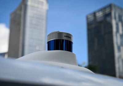
Until 2018, the global LiDAR market was predominantly controlled by US companies. However, Chinese firms such as Hesai, Robosense, Seyond, and Livox have significantly expanded their market share, with Hesai alone holding 47 percent of the global market. This expansion is supported by Chinese Communist Party (CCP) industrial policies, including tariffs and subsidies, and the strategy of civil-military fusion. Chinese companies are required under China's National Security Law to provide data collected by their products to the CCP. This poses national security risks for the US, as it suggests potential access to sensitive data on US infrastructure and military systems.
LiDAR Associated Security Risks
Concerns include the risk of cyberattacks and malware introduction via software updates from Chinese LiDAR equipment. Hesai has acknowledged that the PRC government has significant authority over its operations. Additionally, many LiDAR systems use Field Programmable Gate Array (FPGA) semiconductor chips, which are currently not subject to US export controls. Two US companies, Xilinx Inc. and Altera Corporation, dominate the FPGA market, raising concerns that Chinese LiDAR companies might be leveraging US-made FPGAs in systems that could support the PRC military’s autonomous vehicles.
The US Response
In January 2024, the US Department of Defence (DoD) placed Hesai on its 1260H list of “Chinese military companies,” marking the first LiDAR manufacturer and publicly traded company to be included. In March 2024, the Bureau of Industry and Security (BIS) proposed a rule to identify foreign information and communications technology essential to autonomous vehicles, explicitly mentioning LiDAR. In May 2024, a US defence spending bill advanced by the House of Representatives included a measure to prohibit the US DoD from using Chinese LiDAR equipment in military systems.
These actions are part of the broader US strategy of decoupling from China, highlighted by the CHIPS and Science Act of 2022. This situation serves as a warning for countries like India, which remains heavily dependent on Chinese imports. To mitigate risks and compete effectively, India needs to strengthen its manufacturing and industrial base, especially in strategically important technologies like LiDAR.
Conclusion
The rise of LiDAR technology and its increasing dominance by Chinese firms underscore the dual-edged nature of technological advancements. While LiDAR offers significant benefits across various sectors, its growing market presence in China raises serious national security concerns, particularly for the US. These concerns highlight the need for countries like India to bolster their technological and manufacturing capabilities to reduce reliance on foreign technologies. As LiDAR technology continues to advance, India must navigate these challenges and leverage the technology's potential to drive progress in infrastructure, urban planning, and other critical areas while ensuring national security and technological sovereignty.
|
Probable Questions for UPSC Mains 1. Assess the strategic importance of LiDAR technology in modern defense and infrastructure planning. How does the global dominance of Chinese firms in the LiDAR market impact national security for countries like the United States and India? Discuss the potential implications for global technology supply chains and suggest measures that countries would take to mitigate these risks. (10 Marks, 150 Words) 2. LiDAR technology has shown significant promise in various sectors such as urban planning, agriculture, and disaster management. Evaluate the challenges associated with the deployment of LiDAR in India, particularly in terms of data accessibility and technical expertise. How can India leverage advancements in drone technology and LiDAR systems to enhance its infrastructure and disaster management capabilities while addressing these challenges? (15 Marks, 250 Words) |
Source: ORF India


