Context:
An earthquake around 2,500 years ago could have caused the Ganga river to abruptly change course, according to a new study published. Researchers said the “undocumented” quake, possibly of magnitude 7-8, rerouted the main channel of the river in present day Bangladesh, a country vulnerable to big seismic shocks.
Discovery of Sand Dikes
In 2018, geochronologist Elizabeth Chamberlain and her team from Wageningen University & Research, Netherlands, were studying river channel movements in the Ganges delta. They examined a well-preserved “paleochannel”—a 2-km-wide archive of the river's ancient course—about 45 km south of the modern Ganga river, currently used for rice cultivation.
The team discovered two large sand dikes a kilometre east of the paleochannel. These dikes were formed by liquefaction, a process where earthquakes disturb the river bed, causing sediments to flow like a liquid. This finding provided the first evidence that earthquakes can alter river courses.
Key Findings of the Paper
Change in Course
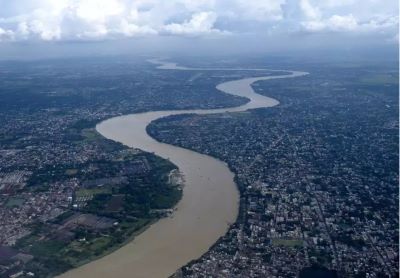
The study provides the first confirmed instance of an earthquake causing a river avulsion in deltas, particularly for a large river like the Ganga. This phenomenon, known as an avulsion, involves a significant change in the river's course. Satellite images revealed the former main channel of the Ganga, located about 100 kilometres south of Dhaka, Bangladesh. This channel, now a low-lying area about 1.5 kilometres wide, extends intermittently for roughly 100 kilometres parallel to the current river course.
Possible Sources of the Earthquake
The earthquake responsible for the avulsion could have originated from one of two sources. The first possibility is a subduction zone to the south and east, where an oceanic crust plate is pushing beneath Bangladesh, Myanmar, and northeastern India. The second potential source is the large faults at the base of the Himalayas to the north, which are gradually rising due to the ongoing collision between the Indian subcontinent and the rest of Asia.
Instantaneous Avulsion
Rivers typically take years or even decades to alter their course, but an earthquake can induce an avulsion almost instantaneously.
Earthquake Evidence and Timing
Origin of the Earthquake
While the exact origin of the earthquake remains uncertain, researchers speculated it could have originated either in the Indo-Burma mountain ranges or the hills of Shillong—both areas where the Indian and Eurasian tectonic plates meet. The impact of the earthquake was substantial, regardless of its origin.
Earthquake's Role in the Ganga River's Avulsion
The researchers' analysis led to the conclusion that an earthquake with a magnitude of 7 to 8, occurring around 2,500 years ago, was responsible for the Ganga's abrupt course change. To determine the timing of the earthquake and the river avulsion, they used optically stimulated luminescence (OSL) dating.
OSL dating estimates how long mineral grains have been buried by measuring the natural radiation stored in them. By shining blue light on the grains, researchers could measure the trapped energy released as photons, which indicated the time the grains were buried. The OSL dating of samples from the paleochannel and sand dikes matched, confirming the earthquake’s role in the river’s avulsion.
|
Earthquake
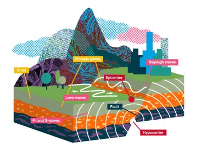
● An earthquake occurs when the Earth's crust shakes due to the release of energy that generates waves travelling in all directions. This energy is released along a fault, which is a fracture in the crustal rocks. ● Rocks on either side of a fault move in opposite directions. Friction caused by the pressure of overlying rock strata initially keeps them together. ● However, the stress eventually overcomes this friction, causing the rocks to deform and slide past each other abruptly. This movement releases energy, producing waves that radiate outward. Key Terms Related to Earthquakes ● Focus (or Hypocentre): The point within the Earth where the earthquake originates. ● Epicentre: The point on the Earth's surface directly above the focus, and the first location to experience the seismic waves. |
Future Hazards and Implications
● Potential Consequences of Earthquake-Induced River Avulsions: This discovery highlights the potential for large earthquakes to trigger significant river avulsions, which can have severe consequences. The cascading effects of such events can include devastating floods, particularly in densely populated regions like the Ganges-Meghna-Brahmaputra delta, which houses an estimated 630 million people.
● Exacerbation of Risks by Human Activities and Climate Change: The risk of river avulsions is exacerbated by human activities and climate change. Factors such as rapid subsidence from widespread embankment and rising sea levels due to climate change increase the likelihood of such events.
● Need for Future Research and Forecasting: Future research should focus on understanding the frequency of quake-driven avulsions and developing forecasting methods.
● Economic Impact: Many regions depend on the Ganga for irrigation. A change in the river’s course could disrupt water supply, leading to crop failures and loss of livelihood for farmers. Infrastructure such as bridges and dams along the original river course would either become obsolete or require significant modifications. Flooding would also contribute to infrastructure damage.
● Social Impact: A sudden shift in the river’s course could lead to mass displacement of people. Alterations in water availability and quality could impact public health, especially in regions already facing challenges with clean water access.
● Importance of Coordinated Regional Preparedness: Dr. Hanebuth emphasised the need for coordinated research and preparedness efforts among India, Bangladesh, and Myanmar to mitigate risks associated with such events. He stressed that geological and climatic issues transcend political boundaries and require collaborative efforts for effective management.
● Geopolitical Impact: Since the Ganga flows through multiple states in India, its course change could lead to conflicts over water rights and resource allocation.
Conclusion
Researchers discovered that an earthquake approximately 2,500 years ago, with a magnitude of 7 to 8, caused the Ganga river to shift its course. The use of optically stimulated luminescence (OSL) dating confirmed the timing of the earthquake and the river's avulsion. The findings underscore the potential for earthquakes to trigger severe river avulsions and the need for comprehensive preparedness and international collaboration to manage such risks.
|
Probable Questions for UPSC Mains 1. Discuss the role of seismic activities in altering river courses, with reference to the recent study on the Ganga River. How can such natural phenomena impact densely populated regions like the Ganges-Meghna-Brahmaputra delta? Analyse the implications for flood management and regional planning. (10 Marks, 150 Words) 2. Examine the use of optically stimulated luminescence (OSL) dating in geological studies. How did this technique contribute to understanding the cause of the Ganga River’s avulsion approximately 2,500 years ago? Evaluate the importance of advanced dating methods in reconstructing historical geological events and their relevance for current flood risk assessments. (15 Marks, 250 Words) |
Source: The Hindu


