Date: 06/04/2023
Relevance: GS-2: Bilateral, regional and global groupings and agreements involving India and/or affecting India’s interests.
Key Phrases: standardized, Anjaw, and Subansiri, Wo’gyainling”, “Bumo La”, Sir Henry McMahon, Ministry of External Affairs, Simla Conference, Mechuka or Menchuka.
Context:
- In an effort to lay claim over Arunachal Pradesh, Beijing has renamed 11 places in the northeast Indian state that it says are part of South Tibet. The move drew a sharp reaction from India.
Key Highlights:
- This isn’t the first time that China has done something like this.
- It released two different sets of “standardised” names of places in Arunachal Pradesh back in 2017 and 2021.
- China claims some 90,000 sq km of Arunachal Pradesh as its territory.
- It calls the area “Zangnan” in the Chinese language and makes repeated references to “South Tibet”.
- China makes periodic efforts to underline this unilateral claim to Indian territory.
- Giving Chinese names to places in Arunachal Pradesh is part of that effort.
- The latitude and longitude listed with the names showed those places as Tawang, Kra Daadi, West Siang, Siang (where Mechuka or Menchuka is an emerging tourist destination), Anjaw, and Subansiri respectively.
- These six places spanned the breadth of Arunachal Pradesh — “Wo’gyainling” in the west, “Bumo La” in the east and the other four located in the central part of the state.
Do you Know?
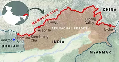
- The McMahon Line extends for about 550 miles from Bhutan in the west to the border of Myanmar in the east.
- India considers the McMahon Line as the official boundary between China and India in the Northeast region.
- The McMahon Line passes through one Indian state, which is Arunachal Pradesh.
Historical background of the McMahon Line and the reasons behind China's rejection of it.
- The McMahon Line is a boundary line drawn in 1914 during the Simla Conference, held between the British and the Tibetans.
- The conference was intended to resolve the boundary dispute between Tibet and British India, as the Chinese government had lost control over Tibet in the early 20th century.
- The line was named after the British negotiator Sir Henry McMahon, who drew it up during the conference.
- It stretches from Bhutan's border to the Tibetan plateau, and is considered the effective boundary between India and Tibet.
- However, China has always disputed the McMahon Line and the entire northeastern Indian state of Arunachal Pradesh as its territory.
- China bases its claims on historical and cultural ties between Tibet and China, as well as on the fact that Tibet was part of China's territory.
- Additionally, China claims that the line was not agreed to by the Chinese representative at the conference, and therefore has no legal basis.
- China also asserts that the McMahon Line was drawn by British colonial rulers to expand their territorial control, without any consultation with the Chinese government.
- As per China's claims, it was not even a party to the Simla Conference as it was not recognized as a legitimate government at that time.
- Furthermore, China also cites the so-called "McMahon-MacDonald Line," which was a revised proposal made by the British and Chinese representatives in 1918, as evidence of the McMahon Line's illegitimacy.
- The revised proposal was never ratified by either side and was eventually abandoned.
- China's rejection of the McMahon Line is based on its historical and cultural claims over Tibet and its opposition to the colonial-era boundary demarcations imposed by foreign powers.
- The issue has been a contentious one and has led to tensions between the two countries.
Significance of the current Move:
- China claims Arunachal Pradesh as its territory, and releasing standardized names for places in the region is part of its efforts to underline its unilateral claim to the area.
- The move is seen as an attempt to prove China's territorial jurisdiction over Arunachal Pradesh.
- Chinese maps show Arunachal Pradesh as part of China, and sometimes parenthetically refer to it as "so-called Arunachal Pradesh."
- China has made periodic efforts to assert its claim over Indian territory, and giving Chinese names to places in Arunachal Pradesh is part of that effort.
India's Response:
- In a statement, India's Ministry of External Affairs spokesperson categorically stated that "Arunachal Pradesh is, has been, and will always" be an integral part of India.
- India has condemned China's act of renaming places in Arunachal Pradesh in the past as well.
- India has reiterated its sovereignty over Arunachal Pradesh and stated that China's actions will not change the facts on the ground.
Conclusion:
- Despite India's firm response to the move, China continues to dispute the legal status of the McMahon Line and makes periodic efforts to underline its unilateral claim to Indian territory.
- It is crucial for India to remain vigilant and take necessary steps to protect its territorial integrity and sovereignty.
- At the same time, it is also essential for both countries to engage in constructive dialogue to resolve the border dispute and maintain peace and stability in the region.
Source: The Indian Express
Mains Question:
Q. China has repeatedly claimed Arunachal Pradesh as its own territory and has even gone so far as to rename places in the region. What is the basis of China's claims, and how has India responded to them? (250 Words).


